


Table of Contents
![]()
Feature Article
Creating and Distributing High Resolution Cartographic
Images
David Yehling Allen
Map Collection, Melville Library, SUNY Stony Brook
dyallen@notes.cc.sunysb.edu
Introduction
Maps and other cartographic materials are popular items for
digitization and display on the Internet. Antique or historical maps,
contemporary maps, aerial photographs, and satellite images can all
be found on the World Wide Web. This article will focus on the
reformatting of paper maps as computer-readable images, both for
purposes of preservation and for access through CDs or on the Web.
Maps digitized from originals on paper almost always need to be in raster format, in which the image is formed by a grid of dots or pixels. Many of the maps found on the Internet are vector maps, which are created from mathematically defined lines and curves. Vector maps are usually produced by Geographic Information Systems (GIS) software, and are typically used in interactive programs, such as the Census Bureau's TIGER Map Service. Vector maps are more versatile than raster images. Vector maps can be easily rescaled; they can be made to display information in multiple layers; and they can be used to create thematic maps derived from geocoded information contained in databases. But the vector format is not suitable for digitizing paper maps, especially historical maps. The wide variety of fonts, images, and lines on antique maps are virtually impossible to translate into vector images.
The quality of raster images on the Internet varies greatly. Many can best be described as "evaluation quality" images - they give a good idea of the overall appearance and contents of a map, but do not preserve enough detail for many research purposes. "Research quality" images preserve all of the significant details on maps (such as street names and contour lines). "Preservation quality" images are scanned to the same or higher resolution as research quality images, but are more carefully controlled for image quality and consistency. There are no widely recognized standards for "research quality" or "preservation quality" images, but de facto standards are beginning to emerge, at least for research quality images, and will be discussed below.
For those who want to sample the wide variety of cartographic sites on the Web, the following are good starting points. The largest collection of small scale reference maps is probably at the Perry-Castenada Map Library at the University of Texas at Austin. Typical collections of "evaluation quality" images of historical maps can be found at the Hargrett Library at the University of Georgia (maps of Georgia and the Southeast); the University of Arizona (maps of the Southwest); SUNY Stony Brook (maps of New York); and the Osher Map Library at the University of Southern Maine (maps of New England). Those who want a comprehensive listing of digitized maps on the Internet can find one at Odden's Bookmarks. Few of the maps at these sites are digitized at a high enough resolution to qualify as research quality images.
Creating High Resolution Images of Maps
There is by now a good deal of consensus as to what does
constitute a research quality image. An important study conducted at
Columbia University, the
Oversized Color Image
Project, concluded that, in the case of most maps, all of the
essential details could be captured at 200 dpi in 24-bit color. The
Library
of Congress has adopted a 300 dpi 24-bit standard for its map
digitization projects, and this is likely to become the de facto
standard for similar projects. The
National Archives
has adopted essentially the same standard, although concerns about
file size have led that institution to scan maps larger than 11 x 17"
at 200 dpi (1). Digitization at 300 dpi with
24-bit capture leaves some room for error, and even makes it possible
in many cases to discern such details as paper texture. Although this
standard does not satisfy all conceivable needs, very few researchers
require more detail. It should be noted, though, that black and white
maps do not necessarily have to be scanned in color. Gray scale and
bitonal scanning are options for uncolored maps. As will be seen
below, the National Oceanic and Atmospheric Administration (NOAA) is
doing bitonal scanning of black and white Coast Survey charts. When
bitonal scanning is used, materials are scanned at a higher
resolution (between 600-800 dpi) to gain image quality comparable to
300 dpi 24-bit color scanning, but the size of the bitonal files is
still much smaller than the color.
It is actually quite easy to produce 300 dpi 24-bit color images using standard off-the-shelf equipment. At the University of Connecticut, the map librarian has been scanning maps in sections on an ordinary commercial scanner at 300 dpi, and then tiling the images or knitting them together using Adobe Photoshop. The resulting images are quite presentable, and researchers viewing them over the Web can indeed see all of the significant details.
Still, such images do not satisfy the exacting requirements of some granting agencies, and cannot be depended upon to consistently meet the needs of researchers. To consistently deliver acceptable quality, a number of other criteria need to be met. These include the use of precision equipment, careful control over production processes, systematic evaluation of image quality, and adequate metadata. The technical issues involved in producing high quality images have been described elsewhere (2). Although the process is demanding and expensive, a number of institutions are producing digital images of maps that meet these criteria. These images are created using oversized scanners or expensive digital cameras, which can now produce images up to 10,000 by 10,000 pixels (3). Such devices can produce high quality digital images at 300 dpi in 24-bit color from maps up to approximately 30" x 40". Larger or irregular maps still have to be dealt with by tiling images, or by knitting them together with a program such as Photoshop.
It is debatable whether even the high-quality research images described above constitute "preservation quality" images. There is, of course, an ongoing discussion about whether digitization is a viable means of preserving anything. Much of this debate hinges on such issues as the durability of digital documents, and goes far beyond the scope of this article. More directly relevant are the issues of color appearance and image resolution. Complete color matching is not of much concern to typical map users, although colors need to be rendered accurately enough to distinguish between the different subjects on thematic maps, and to correlate map legends to content regions. Still, if a preservation quality image is to constitute a permanent record of a map, one might well refuse to settle for anything less than full color matching. Even more thorny is the question of how much resolution is needed for preservation purposes. Although 300 dpi is adequate for perhaps 99% of all current research, what about the remaining one percent? And what about possible future research projects that we cannot even foresee? Questions like these make it almost impossible to visualize a standard everyone will accept.
As a partial response to these questions, several government agencies scan maps at higher resolutions than they use for access purposes. The U.S. Geological Survey, for example, has been scanning its topographic maps at 500 dpi, and then resampling the images at 250 dpi for distribution. These are the Digital Raster Graphic (DRG) data files that the USGS has been sending to depository libraries on CDs. Similarly, both the National Archives and NOAA (in projects discussed elsewhere in this article) distribute scaled down versions of their images over the Internet. These efforts, however, have as yet led to no consensus as to whether it is really necessary to scan master images at a higher resolution than 300 dpi in 24-bit color, and no agreed-upon minimum resolution for such archival images appears to be emerging.
The most important practical problems confronting the producers of digital images of maps arise from the huge size of raster image files. A fairly ordinary sized map, such as a topographic map measuring 22"x 27", digitized at 300 dpi in 24 bit color, will produce an uncompressed file 160 Mb in size. It is not unusual for digitized maps to occupy files much greater than 200 Mb, and some individuals are producing files of more than 500 Mb for a single map. Images of this size can be compressed with little or no loss and distributed on CDs. Thus the Digital Raster Graphic maps mentioned above are being distributed as "pack bits compressed" TIFF files, which occupy about 12 Mb each. These large files can be compressed even further with little perceptible loss of information using emerging compression techniques. The advent of DVDs, which can hold several times as much data as CDs, should further facilitate the distribution of high quality digital images of maps (4).
Distributing High Resolution Cartographic Images on the
Internet
One of the biggest challenges confronting the producers of high
quality digital images is their distribution on the Internet. These
gigantic files create multiple problems. They make heavy demands on
server space. They take a long time to transmit, especially to those
who do not have access to high-speed networks. And they make
excessive demands on computers with little memory, limited hard
drives, or inadequate displays. Once one of these large files is
downloaded, only a small portion of the map can be displayed on
normal monitors at any given time, and some users find it difficult
to use maps without having the entire map in front of them.
In spite of these obstacles, great ingenuity has been shown in developing ways to transmit maps in digital form over the Internet. The remainder of this article will be devoted to exploring several sites that illustrate various approaches to this problem.
Perhaps the simplest approach is illustrated by a site managed by the National Oceanic and Atmospheric Administration (NOAA). NOAA has recently made available on the Web a spectacular Historical Map and Chart Collection. As noted earlier, maps in this collection were originally digitized for archival purposes at 800 dpi. Because many of the original charts were black and white, much of this scanning was bitonal, with 24-bit color being reserved for colored maps. The file size of the 800 dpi bitonal images averages a relatively small 5-10 Mb; similarly sized color maps result in images that are 24 times larger. For distribution purposes, the user can view "evaluation quality" 100 dpi GIF images using a standard Web browser. Those who need higher quality maps can download 300 dpi TIFF images. The file size of most of the resampled bitonal images is under 1 Mb; the size of the color images is greatly reduced by resampling them to 8-bit color. This is a distinctly "low tech" solution, but it does provide reasonably good access to an outstanding collection (5).
Another "low tech" approach to distributing large map images is "tiling." A good example can be found at the University of Connecticut site, where the 1834 Tanner map of the United States has been divided into 60 sections or "tiles." Each section is approximately 500 Kb, and can be displayed by clicking on the corresponding tile on a low resolution index map. This approach suffers from two drawbacks. Creating such a tiled image is quite labor intensive, and tiled images are at best cumbersome for the user who needs to simultaneously examine information displayed on two or more adjacent tiles.
Tiling combined with other techniques can overcome some of the limitations of tiling alone. The Atlantic Neptune Online is well worth visiting for its creative use of tiling in combination with three different zoom levels.
Another innovative approach to distributing map images on the Internet has been taken by the National Library of Iceland with its Icelandic Map Project. This ambitious project involves the creation of a comprehensive online library of historical maps of Iceland. Maps were scanned from 6 x 7 cm positive color slides using a Kontron film scanner to produce 3,500 x 3,500 pixel images in 24-bit color. The master images, which average about 35 Mb in size, are stored on CDs as TIFF files with LZW compression. Derivative images in PNM (Portable Anymap) format are stored on a server for access on the Web. These derivatives are accompanied by JPEG images in three resolutions for quick display on different screen sizes (640 x 480 pixels, 800 x 600 pixels, and 1,024 x 768 pixels). The resolution of the JPEG images can be doubled by clicking on them (this highest resolution is derived "on the fly" from the PNM derivative on the server). The images are accompanied by two thumbnails. One of the thumbnails is used for display with text. The second is displayed with the enlarged map images. Displaying the thumbnail together with an enlarged section of a map is a useful innovation, which makes it considerably easier for the user to comprehend the relationship between a particular portion of a map and the map as a whole. Unfortunately, even the highest resolution is not adequate to capture all of the significant details on large maps. The maximum resolution is constrained by the 3,500 x 3,500 pixel file size, and by the loss of resolution involved in converting film images to digital files (6).
The most interesting and promising solutions to distributing maps on the Internet involve innovative software programs. In my opinion, the best results so far have been obtained using the Multi-resolution Seamless Image Database (MrSID) software developed by a company called LizardTech. This software combines high quality wavelet compression with a technology that allows users to zoom in on small portions of a map (7). MrSID is quite flexible, enabling users to examine a map at a variety of levels of magnification without the restrictions imposed by tiling. Because MrSID displays only as much of a map as will fit on the screen, only a small part of the image files needs to be downloaded at a time. The best known application of MrSID is the Panoramic Map Project at the Library of Congress. It has also been used at a number of other sites, including: The San Francisco Bay Area Orthophotoquad Project of the United States Geological Survey; the Illinois Aerial Photograph Digital Archive at the University of Illinois at Urbana-Champaign; and a large historic map collection from the Virginia Board of Public Works at the Library of Virginia.
In spite of its impressive performance, MrSID has some drawbacks. It requires a browser "plug in," and downloading times are still significant. For those with powerful computers it is much easier to scroll around a single high-resolution image of an entire map than to examine it a bit at a time over the Internet using MrSID. LizardTech has addressed this latter problem by making available a free viewer, which works with downloaded images in MrSID format, and also allows one to convert these images into TIFF and other formats for editing. But not all institutions that make their images available in MrSID format permit the downloading of whole files, and this procedure may be too cumbersome for the casual user.
Software in this area is rapidly developing, and there are products on the market that might be used quite effectively with cartographic materials. An example is FlashPix, which was discussed in the April 15, 1998 issue of RLG DigiNews (8). FlashPix has zooming capabilities similar to MrSID (although it works with tiled images), but it can be used with a wide variety of file formats. To the best of my knowledge, FlashPix has not been used in any major cartographic imaging projects, but its capabilities are demonstrated by a test application using images supplied by the U.S. Geological Survey at the Hewlett Packard OpenPix Web site. Another interesting product can be found at a site maintained by the Fine Arts Museums of San Francisco. Its ImageBase utilizes yet another promising software program, the Grid Pix software suite, to zoom in on large images, although here it is used for paintings rather than maps (see Featured Web Site).
Improvements in software, in the storage capacities of servers, in Internet transmission speeds, and in desktop computer processing and display capabilities will no doubt facilitate the use of high-quality digital images of maps over the Internet. However, we are still far from perfection in this area. Downloading times are unacceptable for many purposes, especially for those who must use maps in conjunction with text. For many users the most practical short-range solution may be the purchase of high-quality map images on CD-ROMs or on DVDs. I know that some individuals with an interest in historical maps have been exploring the possibility of marketing such a product, and it may prove economically feasible to sell a variety of maps in this format.
(1)The technical guidelines for digitization projects at the Library of Congress are available at http://memory.loc.gov/ammem/formats.html. The technical guidelines for digitization projects at the National Archives are described in two PDF files that can be downloaded at www.nara.gov/nara/vision/eap/eapspec.html.
(2) Issue No. 12 (1997) of Meridian (the journal of the Map and Geography Round Table of the American Library Association) is devoted to the digital imaging of cartographic materials. Footnotes to the articles in that issue provide access to most of the relevant literature.
(3) Flatbed scanners are usually used preferred for imaging projects, since they are least likely to damage fragile materials. The largest flatbed on the market is made by Tangent Color Systems, a division of Scangraphics Corporation. It can copy materials up to 24 x 36" in size, and is being used by the Library of Congress. For materials which are sufficiently durable, roller scanners are also an option. The National Ocean Service is using a color roller scanner made by ANAtech Corporation. According to Curtis Loy, Chief of the Cartographic Technology Program, the large size of many of the Coast Survey Charts necessitated the use of a roller scanner, and he claims that "through judicious use of transparent sleeves to protect fragile documents," no document has been damaged (e-mail communication to the author).
The resolution of digital cameras is continually increasing, and they are becoming a very competitive option for digital imaging projects. The most powerful camera on the commercial market appears to be the Phase One Power Phase, which has a resolution of 7,000 x 7,000 pixels for medium format cameras (6,000 x 8,400 pixels for large format cameras). Stokes Imaging has recently had a 10,000 x 10,000 pixel camera constructed for its own work, and doubtless cameras of this resolution will soon become more widely available.
It is, of course, also possible to digitize maps by photographing them and then digitizing the resulting negatives or transparencies (as is done in the Icelandic Map Project). Although reasonably good results can be obtained in this way, image resolution and color quality are difficult to control when a photographic intermediate is used, and this method is not recommended if image quality is the most important consideration. On the other hand, processes such as Kodak Photo CD are relatively easy to use and inexpensive, and are fully adequate for many purposes. See Anne R. Kenney and Oya Y. Rieger, "Using Kodak Photo CD Technology for Preservation and Access: A Guide for Librarians, Archivists and Curators." http://www.library.cornell.edu/preservation/kodak/cover.htm.
(4) See Steve Gilheany, "The Promise of DVDs for Digital Libraries," RLG DigiNews, Vol. 2, No. 3, June 15, 1998. http://www.rlg.org/preserv/diginews/diginews23.html#technical1.
(5)Technical information on the Historical Map and Chart Collection was supplied by Curtis Loy, Chief, Cartographic Technology Program, Coast Survey Development Laboratory. Color images are hard to find in this project, but some can be found among the topographic and Civil War maps.
(6)Technical information supplied by Thorsteinn Hallgrimsson and Björn L. Þórðarson of the Icelandic Map Project. Some additional information on this project: The JPEG files used in this project have a CGI file name extension to indicate that they are script generated (users of many software programs will have to change the name extension to JPG to read the images). Because of problems with scanning from photographic intermediates, a digital camera has been purchased for this project, and plans are underway to recapture all digital files directly from the original using the camera.
(7) Both MrSid and Wavelet compression are discussed by Steven Puglia, "Fractal and Wavelet Compression," RLG DigiNews, Vol 2, No. 3, June 15, 1998. http://www.rlg.org/preserv/diginews/diginews23.html#technical2.
(8) See Kevin Donovan, "The Promise of the Flash Pix Image File Format," RLG DigiNews, Vol. 2, No. 2, April 15, 1998. http://www.rlg.org/preserv/diginews/diginews22.html#FlashPix.
Technical Feature
Imaging Production Systems at Corbis Corporation
Sabine Süsstrunk, Senior Imaging Researcher, Corbis
Corporation
sabines@corbis.com
Introduction
Creating a large digital image archive poses a number of technical
challenges with regards to capturing, processing, storing,
delivering, and managing images. The term "archive" implies that all
digitized images are not only optimized for current work flows and
imaging devices, but also maintain usability on future, as yet
unknown, delivery and output systems. Any production decisions based
on currently available technology have to be made with consideration
to future image uses and markets.
In the case of a commercial digital archive, the digital image is the product as opposed to the image illustrating a product. Customers are making buying decisions by viewing the images either on screen or on hard copy output, and very often both. This implies that the images have to look "perfect" on any given output, with little or no regard to the tone and color content of the original artwork, which can be a photograph or a painting. In most cases, the customer will never have seen the original, or will only have a memory recollection of it. This application clearly differs from most large imaging initiatives in the museums and libraries community.
How best to scan photographs to create digital facsimiles has been described by Dr. Franziska Frey in the December 15, 1997 issue of RLG's DigiNews. (1) This article will describe how Corbis, a large digital image collection with over 1.3 million high resolution digital images, has addressed the complex issues of digitizing images for an archive with commercial applications as illustrated in Figure 1. The images come from the finest professional photographers, museums, cultural institutions, and public and private collections in the world, and are licensed for one-time use. Corbis and its content providers maintain all copyrights and retain non-exclusive rights to market the images. Images that are used in low-resolution form can be delivered over the Web immediately. High-resolution images can be delivered overnight via CD-ROM, or can be sent via Corbis' FTP (in the US) or ISDN (in Europe) service.
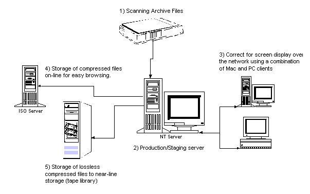
Corbis Archive Production
1. Scanning Archive Files
Corbis uses high-end Scitex and Heidelberg-Linotype CCD and drum
scanners. Although medium priced scanners can currently also produce
high quality image scans, high-end scanners such as the Scitex
Eversmart or the Heidelberg Topaz offer tools and workflow solutions
that allow for higher productivity, such as batch preview and
scanning modes. All of the high-end CCD and drum scanners (price
range between $30,000 and $60,000) on the market today were primarily
developed for the pre-press industry. Although all of them allow an
RGB or CIE Lab output, many of the tools in the scanning software are
optimized for CMYK output, which is not recommended as an archive
color space due to its limited color gamut.
(2)
1.1 Spatial Resolution
Corbis scans images at the optical resolutions of the scanners used,
which vary according to the format of the original. Choosing the
correct scan resolution is dependent on the purpose of the archive.
Although it would be ideal from an archival point of view to digitize
at a level that captures all the information content in an image, in
reality the necessary scan resolutions (up to 4,000 pixels per inch
for modern film material) are hard to achieve with current CCD
scanners for formats larger than 35 mm. The resulting file sizes are
huge, up to 960 Mb uncompressed for a 4 x 5 inch original.
It has to be noted that the scanning resolution in pixels (or dots) per inch is not a good indicator of the resolving power of a scanner or digital camera. The ability of an image capture device to resolve fine detail depends on the whole optical system, including the lens. To get a good indication of the resolution capabilities of a scanning system, the modulation transfer function (MTF) should be measured. (3)
Considering that Corbis is a commercial digital image archive, most images will be reproduced on press. Very rarely will a reproduction exceed 11" x 17", the most common sizes are 8" x 10" or less. The number of pixels per inch required for reproduction depends on the screen frequency of the printing process; usually 1.5 to 2 pixels per halftone dot is recommended. For example, a 150 lines per inch reproduction requires a file of the same magnification with 225 to 300 pixels per inch. Corbis' uncompressed archive file sizes vary between 24 Mb and 60 Mb for an image.
1.2 Image Processing
Very little tone and color correction is applied during scanning. The
tone (or gamma) corrections applied are usually to compensate for
under- or overexposure, and high or low key scene content. Color
corrections are limited to cast removal that was unintentionally
introduced in the photographic process. All these corrections use
14-bit or 12-bit controls on the scanners. In practice, these
controls change the non-linear quantization of the 14-bit raw scan
data to the 8-bit image file data per color channel.
Corbis currently does not save raw scan data, i.e., 14-bit or 12-bit per channel scan data. However, the resulting 24-bit RGB or L*a*b (or Lab) archive image is as close to "raw" as one can practically call a 24-bit scan output. It has to be noted that during all 14-bit to 8-bit quantization of image data on commercial scanning products, the data are interpreted in a non-linear way. Selecting white point, black point, and adding tone and color correction will influence which 8-bit data of the initial linear 14-bit scan signal per channel are retained for the image file. This transform is image dependent and usually not captured during the scanning process, so there is no practical way to recreate raw scan data, or recreate original image data. As Corbis is not in the business of creating digital facsimiles, but excellent image reproductions, that trade-off is seen as an acceptable compromise.
2. Production and Staging Server
The production and staging server, called IVAN, has taken over the
function of many manual processes in archive production. After the
archive images are downloaded to the server, low resolution image
files and histograms are created for initial quality control. Severe
image artifacts, such as corrupted scanner look-up tables or clipping
in one of the color channels, can therefore be caught early in the
production process, and the image can be sent back for rescan. At the
same time, the operator ensures that the image identification of the
file is the same as the bar code number on the original. Archive
image attributes, such as color space, pixel width, pixel height,
file format, creation date, etc., are automatically recorded and
passed to the image tracking database (ITD). The unprocessed archive
images are then moved to the hierarchical storage management (HSM)
system for near-line storage (see 5).
After processing, the images are staged for a second quality assurance step. The QA technicians evaluate the quality of processing by thoroughly examining the image file, and comparing it to the original. After QA, three additional low resolution image copies are created (see 4), and the processed images are moved to the HSM system for near-line storage.
3. Image Processing
A resampled copy of the image file (1,280 by 1,024 pixels) is
staged on the IVAN production server for Corbis' imaging technicians
to access. The technicians, working in a calibrated viewing
environment, process the images to a "pleasing color" standard.
Pleasing color is defined as global tone corrections to adjust the
contrast of the images to the defined output, and to emphasize image
specific content. The defined output is a monitor, calibrated to a
white point of 6500° Kelvin and a gamma of 1.8. The ambient
light is low, resulting in very little viewing glare on the monitor.
Color is globally adjusted to balance the image. Additionally, dust
and scratches are removed from the image.
(4)
The above described image processing steps lead to the creation of an access file. As defined in the archival community, an access file is optimized for a given purpose and output. Corbis intends the access files for monitor viewing. They are used in CorbisViewä, the Corbis image search engine that allows customers to search and preview images and other on-line offerings that can be found on the Corbis Web site (see www.corbis.com). They are also sold to multimedia publishers for on-line and CD-ROM publishing. A resolution of 1,280 by 1,024 pixels offers a full screen image display on a 17 inch, 24-bit enabled monitor.
4. Storage of Compressed Files for On-line Viewing
Corbis stores three resolutions of its access files on-line: a
thumbnail, a small preview file with maximum pixel dimensions of 256
pixels (height or width of the image), and a larger preview file with
maximum pixel dimensions of 480 by 640 pixels. These files are
accessed for previewing by all Corbis applications, internal and
external. The images are compressed using JPEG.
5. Near-line Storage
Corbis uses a hierarchical storage management (HSM) system to manage
the storage of the high resolution archive files and the 1,280 by
1,024 access image files. The image files are stored in a robotic
tape library on DLT tapes that have a capacity of 35 Gb (Gigabytes)
of data. The HSM software manages the writing of images to the tapes
and the retrieval of images from the tapes. To the user, the image
seems to still reside on the image server, and can be retrieved by
anyone on the network. The retrieval time of a 30Mb file is about 3
minutes.
The archive images are stored in uncompressed RGB or Lab TIFF format. Lossless compression is achieved by hardware compression when writing the tapes. Corbis does not use a proprietary file format for its archive files. Theoretically, an archive file might not be accessed until the next time the archive is recopied onto the next generation storage medium, which will occur in 7 to 10 years. At that point, source code to interpret the image file format needs to be readily available.
Conclusion
It has been encouraging to see the development of high quality tools
destined for digital image applications other than pre-press.
However, creating true digital facsimiles that allow the recreation
of an original artwork is still very expensive. For commercial
digital collections, such as Corbis', archive files represent
high-quality image scans that allow for good image reproduction but
do not recreate data about the original artwork.
(1) Frey, Franziska. "Digital Imaging for Photographic Collections: Foundations for Technical Standards," RLG DigiNews, vol. 1, no. 3, December 15, 1997. http://www.rlg.org/preserv/diginews/diginews3.html#com.
(2) Scanners and digital cameras capture colors using the RGB (Red, Green, and Blue) or CIE Lab color model, while printers use the CMYK (Yellow, Magenta, Yellow, and Black) model that is based on the absorption of ink into paper. The Lab model is based on the original color model proposed by Commission Internationale d'Eclirage (CIE), and addresses the problem of the variability of color reproduction that results from the use of different monitors or printing devices. L* is a measurement of the lightness of an object, a* is a measurement of red and green channels, and b* is a measure of yellow and blue channels.
(3) Williams, Don. "What is an MTF ... and Why Should You Care?," RLG DigiNews, vol. 2, no. 1, February 15, 1998. http://www.rlg.org/preserv/diginews/diginews21.html#technical.
(4) The defined output is a monitor, calibrated to a white point of 6500° Kelvin and a gamma of 1.8. Most of Corbis' professional image buyers work in the graphic arts community, which still uses the Macintosh as its preferred platform. The Mac traditionally uses a video gamma of 1.8. On the PC platform, the default gamma is 2.2. A mismatch in monitor gamma makes the "1.8 gamma" image appear darker on a 2.2 gamma monitor. Gamma and color temperature are important factors that can determine the quality of an image display. However, the influence of the viewing conditions can override these two factors. In general, for the human eye to fully adjust to the monitor, the ambient light has to be dimmer than the monitor, and the color temperature of the light source illuminating the room has to be lower (warmer color) than the monitor.
|
Highlighted Web Site This project is a collaboration between the Fine Arts Museums of San Francisco and the University of California at Berkeley to provide Web access to high resolution images. One of the distinguishing features of the project is the use of the GridPix format, which allows users to scroll within a large image to view portions at different levels of magnification. Similar to Flashpix file format, GridPix uses a tile-based approach, and enables users to access the higher resolution details of an image within one file. Because it is based on server-scripts, the implementation is entirely in HTML, and can be supported by any graphical Web browser without need for a special software or a plug-in. The Zoom Project Web site further explains the usage of GridPix, and provides examples. |
Calendar of Events
Fourth
International Conference on Knowledge Discovery and Data Mining --
KDD-98
August 27-31, 1998
To be held in New York City, this conference will address the
science and technology of automated discovery, drawing from the
fields of statistics, databases, machine learning, data
visualization, high performance computing, knowledge acquisition, and
knowledge-based systems.
OCLC
Seminars on Knowledge Access Management Tools and Concepts for
Next-Generation Catalogers
Regional Seminar Dates
Minneapolis, Mn., September 14-16, 1998
Philadelphia, Pa.,October 14-16, 1998
Birmingham, England, October 19-21, 1998 and October 22-24,
1998
The OCLC Institute is sponsoring an intensive, interactive seminar
designed for cataloging leaders. The seminar will provide a
comprehensive understanding of cataloging Internet resources--from
selection and collection management to cataloging and catalog
maintenance.
Planning for
Digitization: Bringing Down Another Barrier To Access
September 17-19, 1998
The Western Council of State Libraries is sponsoring in Denver,
Co. a two-day conference designed to inform state libraries and
museum staff about issues they should address in planning statewide
digitization projects. Topics to be covered include: planning
statewide digitization projects, expectations of potential funding
sources, and how to find information once it has been digitized.
The Future of the
Humanities in the Digital Age
September 25-28, 1998
The aim of the conference to be held in Bergen, Norway is to
educate the participants to better understand the convergence of
computing and the humanities. The conference will disseminate
information about ongoing projects, and act as an information broker
at an international level. For further information contact:
futurehum@uib.no.
The Northeast Document
Conservation Center Fall Workshops
The Northeast Document Conservation Center has announced their
next workshop series, which includes three that will be of interest
to anyone working on digital imaging projects. Further information is
available on their Web site or contact: Gay Tracy,
tracy@nedcc.org.
Document Imaging and Document Management Course
October 1-3, 1998
To be held in Los Angeles, Ca., this course is designed to teach
participants how to manage a document imaging system or digital
library. Students will gain an understanding of how document imaging
can be used and managed in both small and large scale organizations.
Students will learn about the technology of scanning, importing,
transmitting, organizing, indexing, storing, protecting, locating,
retrieving, viewing, printing, and preserving documents for document
imaging systems and digital libraries. For further information
contact:
SteveGilheany@ArchiveBuilders.com.
Digital
Imaging for Libraries and Archives Workshop
October 18-23, 1998
The Cornell University Library Department of Preservation and
Conservation will offer a week long workshop on the use of digital
imaging technology in libraries and archives, to be held from October
18-23, 1998 in Ithaca, New York. This is the final session of this
workshop series, as it will be revised and redesigned during 1999.
The next workshop series is tentatively set to begin in October 1999.
Enrollment in the October 1998 workshop is limited to sixteen
individuals to ensure adequate lab time for participants. There are
only a few slots available for this final workshop, and application
information can be found at the
workshop
Web site.
Library and
Information Technology Association (LITA) Announces New National
Institute
November 16-17, 1998
The Library and Information Technology Association is sponsoring
the LITA National Forum 1998: Your Technology Toolkit for 1999 and
Beyond, in Oakland, Ca. The LITA Forum will focus on helping both
decision makers and practitioners in a variety of libraries and
information centers to plan for and manage the technology of the near
future. Topics to be covered include Metadata, Unicode, PC and
workstation security, authentication and certification of users,
technologies for user education, Basic PERL, XML, and Internet2.
OCLC
Institute Workshop on Understanding and Using Metadata
This 2 1/2-day seminar on Understanding and Using Metadata will
be held six times throughout the Fall. The seminar will provide an
intensive theoretical and practical, project-based exploration of
metadata and its applications. Topics include understanding emerging
Web standards such as XML, RDF, and using Dublin Core metadata in
real-world applications. Participants will use the OCLC Institute's
Metadata Lab to design, implement, and evaluate a MARC- or
Webserver-based resource description system using metadata records
for a real-world collection.
Announcements
Final
Report of the Nordic Metadata Project Available
The Nordic metadata project final report is now available in HTML
format. Nordic co-operation in development of Dublin Core tools will
continue in the future. The main goal is the development of tools
needed for creating, gathering, and indexing Dublin Core based
metadata.
The Library
of Congress National Digital Library Program Paper
Available
"Digital Formats for Content Reproductions," by Carl Fleischhauer,
describes the Library's approach to reproducing historical materials,
and lists the types of digital formats selected by the Library for
this purpose. It includes discussion of formats for pictorial
materials, textual materials, maps, sound recordings, and
moving-image materials, and is illustrated with examples. Comments or
questions about this paper can be directed to: Carl Fleischhauer,
cfle@loc.gov.
Digitisation Forum
Online
The Web site from Australia contains over 200 links to sites and
papers relevant to the digitisation process. The goal is to keep
users up to date with the latest developments, to locate other
institutions within the country that are involved in digitisation
activities, and to share expertise and experience in this field.
Library of
Congress/ Ameritech National Digital Library Competition
The 1998/99 guidelines are now available on their Web page. The
deadline for this year's proposals is November 2, 1998.
Digital Vault
Initiative
UMI has announced a massive effort to digitize its 5.5 billion
page archive containing microfilmed documents dating from the first
texts printed in English. UMI will provide electronic access to
Digital Vault Initiative offerings through online bibliographic
databases and both keyword and Boolean searching.
Internet Library of
Early Journals
ILEJ, the Internet Library of Early Journals, a joint project by
the Universities of Birmingham, Leeds, Manchester and Oxford, is
conducted under the auspices of the eLib (Electronic Libraries)
Programme. It has digitised substantial runs of 18th and 19th century
journals, and these images are now available on the Internet together
with their associated bibliographic data.
Digital Initiatives
Database
The Association of Research Libraries (ARL), in cooperation with the
University of Illinois at Chicago (UIC), is developing a database of
digital initiative projects underway at its member institutions. The
database will include digital projects of all sizes and scope
together in one place. The web site is searchable, and lists projects
by host institution, technical focus and subject area, and includes
fuller description of the project, contact information, and a URL.
The database aims eventually to include projects from non-ARL
institutions. For more information, contact: Karen H. Zuidema,
khz@uic.edu.
FAQs
Question:
We heard a rumor that Kodak is dropping the Kodak Photo CD
technology. Is this true?
Answer:
In an attempt to investigate this rumor, we spoke with a number of
Eastman Kodak staff members, and reviewed the recent product
literature and press releases available on Kodak's Web site. Here is
what we found out during this investigation.
Kodak is continuing its support for Kodak Photo CD. The source of this misunderstanding could be Kodak's March 1998 press release announcing the elimination of Kodak Photo CD Imaging Workstation (PIW) from the product line. Kodak Digital Science Conversion System 1200 (CS1200), introduced in June 1996, has replaced PIW. (1) The main force behind this decision seems to be Kodak's interest in providing an open and more flexible environment for its customers and service providers. CS1200 offers many advantages over the PIW:
More information on Kodak Photo CD services and products can be found at the Kodak Digital Cameras and Technology site.
The changes outlined above provide important benefits for institutions that are interested in converting their collections via Kodak Photo CD technology. For example, a service provider's ability to deliver images in different file formats with ICC profiles is an important added feature. Currently, Web access to ImagePac and Flashpix images require a special plug-in (3), and because of this restriction many institutions convert their Kodak Photo CD images to one of the commonly supported Internet file formats, such as GIF or JPEG. The CS1200 export feature will enable service providers to deliver images in a variety of formats to meet their customers' access and preservation requirements.
In addition to the new features that have been incorporated into the CS1200 products, Kodak announced the availability of a new toolkit for Image Pac files. The toolkit, an application programmer interface (API), allows hardware and software developers to author Image Pac files from their products and take advantage of its multiple resolution structure and platform neutrality.
It is important to note that although Kodak has stopped PIW sales, it will continue to provide service and support for these products. Kodak also continues to support both ImagePac (PCD) and Flashpix file formats. Currently the Flashpix file format is being developed and promoted by the Digital Imaging Group that has more than 50 member companies, including Adobe, Canon, Kodak, Fuji, HP, IBM, Intel, Live Picture and Microsoft. Decisions that affect and shape the future of Flashpix will be collectively made by the DIG members.
Kodak continues to support all versions of the Photo CD media, Master, Pro Master, and Portfolio II Photo CDs. The key difference among these options is that Pro Photo CD adds another level of resolution,offering 64 Base images at 4,096 x 6,144 pixel dimensions (the highest resolution that can be achieved via a Master Photo CD is 16 Base, 2,048 x 3,072).
In conclusion, Kodak seems to be committed to continue its support for Kodak Photo CD, and there are no plans to discontinue supporting the ImagePac format for the foreseeable future.
(1) Both PIW and CS1200 systems include the essential hardware and software required to scan transparencies and slides. Each one includes a Kodak PCD film scanner, data manager, color monitor, CD writer, thermal dye sublimation printer, and system software. CS1200 system also includes a Kodak Digital Print Scanner with 24-bit color and 600 dpi optical resolution.
(2) Further information on the ICC profile can be found in the Technical Feature section of RLG DigiNews, vol. 1, no.3, December 15, 1997. http://www.rlg.org/preserv/diginews/diginews3.html#hardware&software.
(3) Internet Imaging Protocol (IIP) is developed and promoted by the Digital Imaging Group to allow Web access to Flashpix images without requiring a special plug-in. However, the use of this protocol requires extensive server-based programming to create CGI scripts or server modules. Further information is available at the Internet Imaging Protocol Web site.
RLG News
Joint RLG and NPO Preservation Conference: Guidelines for
Digital Imaging
Applications to attend the Joint RLG and NPO Preservation Conference
on Guidelines for Digital Imaging are now being accepted. This
international conference, which carries the overall theme of
Guidelines for Digital Imaging, will include speakers from the United
States and the United Kingdom, Australia, and Canada. It will be a
working conference, designed for those with experience in digital
imaging projects who wish to contribute toward the development of
international agreement on best practices and uniform approaches to
reformatting of library, archival, and museum collections through
digitization.
In addition to a keynote address given by Anne R. Kenney (Cornell University) there are three major sessions on:
Each of these topics will be addressed by speakers from the US and the UK; conference participants will choose one of the three topics for intensive work to outline common practices and reach consensus on draft guidelines.
Update presentations will be given on:
And an international panel of experts will provide responses to the conference at its close (speakers include representatives from the UK, Canada, and Australia).
For further details on the program and an on-line application
form, see the RLG or UKOLN Web pages at
<http://www.rlg.org/preserv/joint/>
(from North America and Australia)
<http://www.thames.rlg.org/preserv/joint/>
(from Europe) or
<http://www.ukoln.ac.uk>
Mirror site at UKOLN (UK)
Archival Resources: New RLG Service Uses EAD to Enhance and
Provide Access to Finding Aids
In the previous two issues of RLG DigiNews, the RLG News
section has contained information about the use of SGML - and in
particular the Encoded Archival Description (EAD) DTD - to improve
access to finding aids and the collections they describe. For the
past three years, the archival community has worked on the
development of a standard approach for presenting finding aids in the
electronic environment. To enhance access to these important research
tools as they become increasingly available, RLG has created a new
service, Archival Resources, which will provide integrated access not
only to finding aids, but also to the nearly half million descriptive
records of archival collections and items which exist in the RLIN AMC
(Archival and Mixed Collections) file.
RLG has worked closely with the archival community in the evolution of the EAD standard, as it is clearly an important new standard for providing access to complex finding aids. It provides a way of retaining their hierarchical structure and improving access to previously hard to find collections. RLG's centralized indexing and display features gives Archival Resources users powerful searching across finding aids, across collections, across institutions, and across oceans. Archival Resources' content comes from major research, academic, and national libraries, archives, and museums in North America and the UK. More finding aids will continue to be added by RLG's members and like-minded research institutions.
Beginning August 10, you can also explore RLG's new Archival Resources service free of charge, prior to its official release on September 1. For more information about RLG's finding aids program, see the Archival Resources Web site at www.rlg.org/archivalres.html.
Hotlinks Included in This Issue
Feature Article
Atlantic
Neptune Online: http://mercator.cogs.nscc.ns.ca/neptune.html
Hargrett
Library at the University of Georgia:
http://www.libs.uga.edu/darchive/hargrett/maps/maps.html
Hewlett Packard OpenPix
Web site: http://image.hp.com/openpix.html
Historical
Map and Chart Collection:
http://chartmaker.ncd.noaa.gov/ocs/text/MAP-COLL.HTM
Icelandic Map
Project: http://egla.bok.hi.is/kort/english.html
Illinois
Aerial Photograph Digital Archive:
http://images.grainger.uiuc.edu/airphotos.htm
ImageBase:
http://www.thinker.org/imagebase/index.html
Library of
Congress: http://lcweb2.loc.gov/ammem/pmhtml/pandigit.html
LizardTech:
http://www.lizardtech.com
National Archives:
http://www.nara.gov/nara/nail.html
Odden's
Bookmarks:
http://kartoserver.frw.ruu.nl/HTML/staff/oddens/oddens.html
Osher Map Library
at the University of Southern Maine:
http://www.usm.maine.edu/~maps/exhibit2/
Oversized Color Image
Project: http://www.columbia.edu/dlc/nysmb
Panoramic
Map Project at the Library of Congress:
http://lcweb2.loc.gov/ammem/pmhtml/panhome.html
Perry-Castenada
Map Library at the University of Texas at Austin:
http://www.lib.utexas.edu/Libs/PCL/Map_collection/Map_collection.html
Phase One Power Phase:
http://www.phaseone.com
San
Francisco Bay Area Orthophotoquad Project:
http://www.c3.lanl.gov/~bradley/mrsid/bay_area/
Scangraphics Corporation:
http://www.scangraphics.com
SUNY Stony
Brook: http://www.sunysb.edu/library/ldmaps.htm
TIGER Map
Service: http://tiger.census.gov/cgi-bin/mapbrowse-tbl
University
of Arizona:
http://dizzy.library.arizona.edu:80/branches/spc/set/pimeria/intro.html
University
of Connecticut:
http://magic.lib.uconn.edu/exhibits/ScannedMaps/ScannedMaps.html
Technical Features
Corbis:
http://www.corbisimages.com/
Highlighted Web Site
The Zoom
Project: http://now.cs.berkeley.edu/Td/zoom.html
Calendar of Events
Digital
Imaging for Libraries and Archives Workshop:
http://www.library.cornell.edu/preservation/digital.htm
Fourth
International Conference on Knowledge Discovery and Data Mining --
KDD-98: http://www.aaai.org:80/Conferences/KDD/1998/
Future of the Humanities in
the Digital Age: http://www.futurehum.uib.no/
Library and
Information Technology Association (LITA) Announces New National
Institute: http://www.lita.org/forum98/natfor.htm
Northeast Document Conservation Center
Fall Workshops: http://www.nedcc.org
OCLC Institute
Workshop on Understanding and Using Metadata:
http://www.oclc.org/institute/metadata.htm
OCLC Seminars
on Knowledge Access Management Tools and Concepts for Next-Generation
Catalogers: http://www.oclc.org/institute/seminar2a.htm
Planning for
Digitization: Bringing Down Another Barrier To Access:
http://www.aclin.org/webtele/digit.htm
Announcements
Digital Image Database:
http://www.arl.org/did/
Digital Vault
Initiative: http://www.umi.com/hp/Features/DVault/
Digitisation Forum
Online: http://www.digitisation.net.au
Final Report of
the Nordic Metadata Project:
http://linnea.helsinki.fi/meta/nmfinal.htm
Internet Library of Early
Journals: http://www.bodley.ox.ac.uk/ilej/
Library of
Congress National Digital Library Program Paper:
http://memory.loc.gov/ammem/formats.html
Library of Congress/
Ameritech National Digital Library Competition:
http://memory.loc.gov/ammem/award
FAQs
Digital
Imaging Group: http://www.digitalimaging.org/index.html
Internet Imaging Protocol
Web site: http://www.digitalimaging.org/
Kodak Digital
Cameras and Technology:
http://www.kodak.com/US/en/nav/digital.shtml
RLG News
RLG and NPO Joint
Preservation Conference
RLG Archival
Resources: http://www.rlg.org/archivalres.html
![]()
Publishing Information
RLG DigiNews (ISSN 1093-5371) is a newsletter conceived by the members of the Research Libraries Group's PRESERV community. Funded in part by the Council on Library and Information Resources (CLIR), it is available internationally via the RLG PRESERV Web site (http://www.rlg.org/preserv/). It will be published six times in 1998. Materials contained in RLG DigiNews are subject to copyright and other proprietary rights. Permission is hereby given for the material in RLG DigiNews to be used for research purposes or private study. RLG asks that you observe the following conditions: Please cite the individual author and RLG DigiNews (please cite URL of the article) when using the material; please contact Jennifer Hartzell at bl.jlh@rlg.org, RLG Corporate Communications, when citing RLG DigiNews.
Any use other than for research or private study of these materials requires prior written authorization from RLG, Inc. and/or the author of the article.
RLG DigiNews is produced for the Research Libraries Group, Inc. (RLG) by the staff of the Department of Preservation and Conservation, Cornell University Library. Co-Editors, Anne R. Kenney and Oya Y. Rieger; Production Editor, Barbara Berger; Associate Editor, Robin Dale (RLG); Technical Support, Allen Quirk.
All links in this issue were confirmed accurate as of August 10, 1998.
Please send your comments and questions to preservation@cornell.edu .
![]()